A comprehensive model offers insight into risk, structural implications, and collaborative preparedness efforts.
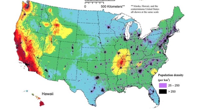
A team of over 50 scientists and engineers from the U.S. Geological Survey (USGS) led a recent study that revealed that nearly 75 percent of the U.S. could face damage from earthquakes. This finding, among others, was a result of the latest USGS National Seismic Hazard Model (NSHM), which used seismic studies, historical data, and advanced data-collection technologies to create a color-coded map pinpointing areas most susceptible to destructive earthquakes.
Updated at the request of Congress, the model has served as a tool for engineers and collaborators to lessen the impact of earthquakes on susceptible communities by providing insights into potential earthquake locations and anticipated tremor intensity.
“This was a massive, multi-year collaborative effort between federal, state, and local governments and the private sector,” said Mark Petersen, USGS geophysicist and lead author of the study. “The new seismic hazard model represents a touchstone achievement for enhancing public safety.”
The updated model—the first to cover all 50 states simultaneously—highlighted changes such as increased risk along the central and northeastern Atlantic Coastal corridor (Washington D.C., Philadelphia, New York, and Boston), as well as heightened potential for shaking in California, Alaska, and Hawaii. With advancements in fault identification and computational modeling, the updated model offers the most detailed assessment to date of earthquake risks across the country.
As the Lord Leads, Pray with Us…
- For Director David Applegate to be discerning as he heads the U.S. Geological Survey.
- For the U.S. Army Corps of Engineers as they contribute to structural improvements to U.S. infrastructure.
- For federal, state, and local public servants as they respond to earthquakes and aftershocks.
Sources: US Geological Survey


